
Thornhill Tomb 15 Yards West North West Of East Malling
Thornhill Tomb 15 Yards West North West Of East Malling, building in East Malling and Larkfield, Tonbridge and Malling, Kent, UK
Ort: East Malling and Larkfield
GPS Koordinaten: 51.28752,0.44026
Neueste Aktualisierung: 13. November 2025 um 01:05

Church of St James
34 m
4 and 6, Church Walk
64 m
Andrewes Tomb 4 Yards North East Of Malling Church
23 m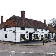
The King And Queen Public House
97 m
Tamarisk Cottage
294 m
Holly Cottage Raven Cottage
282 m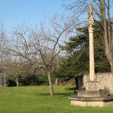
East Malling War Memorial
68 m
24 And 26, High Street
137 m
Kinross Cottage
272 m
45, High Street
156 m
Ingleside
98 m
Paris Farmhouse
454 m
Court Lodge
28 m
11, Mill Street
133 m
The Forge House
158 m
10-16, High Street
113 m
Part of an Iron Age enclosure and a minor Roman villa 128m SSE of the Church of St James
152 m
1-5, Mill Street
103 m
Ivy House Farmhouse
430 m
Wall To North East Of The Limes
327 m
6, The Rocks Road
229 m
69-75, Mill Street
436 m
Barn 30 Yards West Of Ivy House Farmhouse
433 m
Andrewes Tomb 10 Yards North Of East Malling Church
25 m
Andrewes Tomb 6 Yards North Of East Malling Church
24 m
The Limes
344 m
Andrewes Tomb 8 Yards North Of East Malling Church
24 m
The Vicarage
109 mBewertungen
Diesen Ort besucht? Tippe auf die Sterne, um ihn zu bewerten und deine Erfahrung oder Fotos mit der Community zu teilen! Jetzt ausprobieren! Sie können jederzeit kündigen.
Entdecke verborgene Schätze auf jedem Abenteuer!
Von charmanten kleinen Cafés bis zu versteckten Aussichtspunkten – entfliehe dem Touristentrubel und finde Orte, die wirklich zu dir passen. Unsere App macht's dir leicht: Sprachsuche, clevere Filter, optimierte Routen und echte Geheimtipps von Reisenden weltweit. Jetzt runterladen und das Abenteuer mobil erleben!

Ein neuer Ansatz für touristische Entdeckungen❞
— Le Figaro
Alle Orte, die eine Entdeckung wert sind❞
— France Info
Ein maßgeschneiderter Ausflug mit nur wenigen Klicks❞
— 20 Minutes