Skepplanda 55:1, hällristning i Västergötland
Ort: Ale Municipality
GPS Koordinaten: 58.00375,12.16696
Neueste Aktualisierung: 4. November 2025 um 02:34
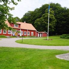
Alvhems kungsgård
1.1 km
Ramstorp Jätteberget
663 m
Sankt Peder 29:3
1.6 km
Sankt Peder 10:1
2.1 km
Krulles Grav
1.9 km
Skepplanda 35:1
1.7 km
Sankt Peder 29:2
1.6 km
Skepplanda 143:1
1.5 km
Skepplanda 53:3
789 m
Skepplanda 123:1
1.9 km
Skepplanda 166:1
1.1 km
Sankt Peder 29:1
1.6 km
Skepplanda 53:2
818 m
Grötåsekarn
2.2 km
Skepplanda 36:1
1.8 km
Skepplanda 60:1
823 m
Skepplanda 59:1
758 m
Skepplanda 39:1
1.3 km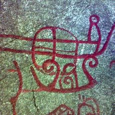
Skepplanda 56:1
151 m
Skepplanda 53:1
834 m
Skepplanda 37:1
1.9 km
Skepplanda 64:2
960 m
Skepplanda 65:1
1.3 km
Skepplanda 114:2
1.4 km
Skepplanda 31:2
2.1 km
Skepplanda 31:1
2.1 km
Skepplanda 5:1
923 m
Ale Golfklubb
1.1 kmBewertungen
Diesen Ort besucht? Tippe auf die Sterne, um ihn zu bewerten und deine Erfahrung oder Fotos mit der Community zu teilen! Jetzt ausprobieren! Sie können jederzeit kündigen.
Entdecke verborgene Schätze auf jedem Abenteuer!
Von charmanten kleinen Cafés bis zu versteckten Aussichtspunkten – entfliehe dem Touristentrubel und finde Orte, die wirklich zu dir passen. Unsere App macht's dir leicht: Sprachsuche, clevere Filter, optimierte Routen und echte Geheimtipps von Reisenden weltweit. Jetzt runterladen und das Abenteuer mobil erleben!

Ein neuer Ansatz für touristische Entdeckungen❞
— Le Figaro
Alle Orte, die eine Entdeckung wert sind❞
— France Info
Ein maßgeschneiderter Ausflug mit nur wenigen Klicks❞
— 20 Minutes