Nutbean Farmhouse, Bauernhaus im Vereinigten Königreich
Ort: Swallowfield
GPS Koordinaten: 51.37240,-0.93993
Neueste Aktualisierung: 20. November 2025 um 08:31
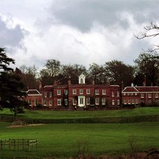
Farley Hall
1.2 km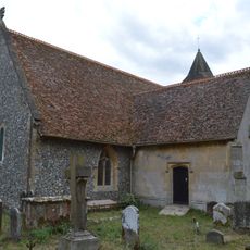
Church of All Saints
896 m
Barn To South East Of Bottom Farmhouse
1.3 km
Clythers
458 m
Swallowfield Cottage The Old Post House
1.4 km
Cordery's Farmhouse
1.3 km
Farley Hill Place Gardens And Adjoining Walls
732 m
Walls Adjoining Farley Hall On North East Corner
1.2 km
Walls And Piers To The Red Lodge
1.4 km
Stables North Of Farley Hall
1.2 km
Glasspool House
1.3 km
Riseley Farmhouse
767 m
Angel Sprints
878 m
George And Dragon
498 m
Pittman Tomb, Approximately 7 Metres North Of The Transept Of The Church Of All Saints
913 m
Drumhead Cottage Thatch Cottage
1 km
The Red Lodge
1.4 km
Bridge Over The River Blackwater At Swallowfield Park
1.3 km
Yew Tree Cottage
955 m
Ford Cottage Whitewater Cottage
1.1 km
Bottom Farmhouse
1.2 km
Tomb Approximately 11 Metres North East Of Chancel Of The Church Of All Saints
901 m
Village Farmhouse
1.4 km
The Marshes Local Nature Reserve
1.1 km
The Poors House
913 m
Icehouse In Swallowfield Park Approximately 420 Metres South East From House
1.1 km
Farleyhill Court
1.1 km
The Old Cottage
839 mBewertungen
Diesen Ort besucht? Tippe auf die Sterne, um ihn zu bewerten und deine Erfahrung oder Fotos mit der Community zu teilen! Jetzt ausprobieren! Sie können jederzeit kündigen.
Entdecke verborgene Schätze auf jedem Abenteuer!
Von charmanten kleinen Cafés bis zu versteckten Aussichtspunkten – entfliehe dem Touristentrubel und finde Orte, die wirklich zu dir passen. Unsere App macht's dir leicht: Sprachsuche, clevere Filter, optimierte Routen und echte Geheimtipps von Reisenden weltweit. Jetzt runterladen und das Abenteuer mobil erleben!

Ein neuer Ansatz für touristische Entdeckungen❞
— Le Figaro
Alle Orte, die eine Entdeckung wert sind❞
— France Info
Ein maßgeschneiderter Ausflug mit nur wenigen Klicks❞
— 20 Minutes