
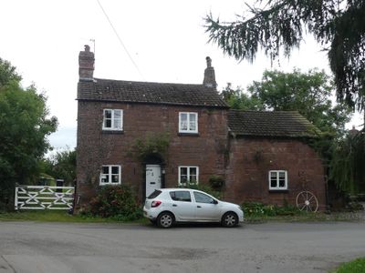
Stone Cottage and attached outbuilding and boundary wall
Stone Cottage and attached outbuilding and boundary wall, Cottage im Vereinigten Königreich

RAF Sealand
1.9 km
Shotwick Castle
1.8 km
Shotwick House
2.5 km
St Michael's Church, Shotwick
130 m
Shotwick Hall
213 m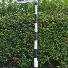
Footpath Guidepost At Junction With Parkgate Road
2.4 km
Gates, gatepiers and churchyard wall along north side of Shotwick Lane
149 m
Front garden walls and gatepiers at Shotwick Hall
212 m
Tombchest of Robert and Martha Ellison, 10 metres southwest of south corner of tower of Church of St Michael
160 m
Manor Farmhouse
23 m
L-shaped ranges of farm buildings 60 metres north of Shotwick Hall
284 m
Footpath Guidepost At Junction Of Pipers Lane Opposite The White House
1.9 km
Granary 30 metres east of Shotwicklodge Farmhouse
1.4 km
Sundial in the churchyard of St Michael
152 m
Greyhound Farmhouse
36 m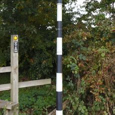
Footpath guidepost 50m east of Heath farmhouse
2.5 km
Tombchest of James Phillips, 2 metres south of the sundial in the Churchyard of St Michael
154 m
Former kitchen or bakehouse attached to north east corner of Shotwick Hall
231 m
Tombchest of Rev M Reay and 4 children, 8 metres south of south porch of Church of St Michael
145 m
Tombchest of John Nevett Bennett, 5 metres west of south porch of St Michael's Church
148 m
Tombchest of William Briscoe (died 1723) and others, 4 metres west of priest's door to St Michael's Church
136 m
Vicarage Farmhouse
79 m
Footpath Guidepost 5 Metres North Of Top Lodge
1.7 km
Barn 70 metres north east of Shotwicklodge Farmhouse
1.4 km
Tombchest of William Briscoe (died 1704) and others, 5 metres southwest of priest's door to St Michael's Church
136 m
North Pair of Aircraft Hangars
1.6 km
South Pair of Aircraft Hangars
1.7 km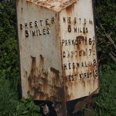
Milepost, Parkgate Road, Woodbank
2.2 kmBewertungen
Diesen Ort besucht? Tippe auf die Sterne, um ihn zu bewerten und deine Erfahrung oder Fotos mit der Community zu teilen! Jetzt ausprobieren! Sie können jederzeit kündigen.
Entdecke verborgene Schätze auf jedem Abenteuer!
Von charmanten kleinen Cafés bis zu versteckten Aussichtspunkten – entfliehe dem Touristentrubel und finde Orte, die wirklich zu dir passen. Unsere App macht's dir leicht: Sprachsuche, clevere Filter, optimierte Routen und echte Geheimtipps von Reisenden weltweit. Jetzt runterladen und das Abenteuer mobil erleben!

Ein neuer Ansatz für touristische Entdeckungen❞
— Le Figaro
Alle Orte, die eine Entdeckung wert sind❞
— France Info
Ein maßgeschneiderter Ausflug mit nur wenigen Klicks❞
— 20 Minutes