
Table tomb to Richard Thomas about 43 metres south of Church of All Saints
Table tomb to Richard Thomas about 43 metres south of Church of All Saints, table tomb in Hollingbourne, Kent, UK
Ort: Hollingbourne
GPS Koordinaten: 51.26472,0.64044
Neueste Aktualisierung: 23. November 2025 um 19:01
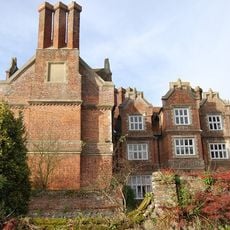
Hollingbourne Manor
250 m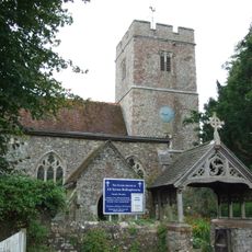
All Saints Church, Hollingbourne
51 m
Bank Cottages
400 m
Woodgate Yew Trees
382 m
The Old Forge
356 m
Wimborne House
943 m
River Farmhouse
929 m
Godfrey House
609 m
64 And 66, Eyhorne Street
932 m
The Old Vicarage
142 m
Grove House
180 m
Six Bells Cottage
108 m
Manor Farmhouse
126 m
Garden Wall About 3 Metres East Of South Wing Of Hollingbourne Manor
227 m
Malt House
332 m
The Pilgrims Rest Inn
352 m
Malt Cottage
311 m
Forge Cottages
361 m
The Old Cottage
90 m
Penn Court
253 m
Garden Wall About 3 Metre East Of Base Of North Wing Of Hollingbourne Manor
251 m
Snagbrook
441 m
Mill House
142 m
Hollingbourne War Memorial
367 m
Table tomb to Edward Charlton about 2.5 metres south of Church of All Saints
37 m
Table tomb about 2 metres north of porch of Church of All Saints
67 m
Table tomb about 2.5 metres east of vestry of Church of All Saints
46 m
Table tomb about 6 metres south of Church of All Saints
30 mBewertungen
Diesen Ort besucht? Tippe auf die Sterne, um ihn zu bewerten und deine Erfahrung oder Fotos mit der Community zu teilen! Jetzt ausprobieren! Sie können jederzeit kündigen.
Entdecke verborgene Schätze auf jedem Abenteuer!
Von charmanten kleinen Cafés bis zu versteckten Aussichtspunkten – entfliehe dem Touristentrubel und finde Orte, die wirklich zu dir passen. Unsere App macht's dir leicht: Sprachsuche, clevere Filter, optimierte Routen und echte Geheimtipps von Reisenden weltweit. Jetzt runterladen und das Abenteuer mobil erleben!

Ein neuer Ansatz für touristische Entdeckungen❞
— Le Figaro
Alle Orte, die eine Entdeckung wert sind❞
— France Info
Ein maßgeschneiderter Ausflug mit nur wenigen Klicks❞
— 20 Minutes